
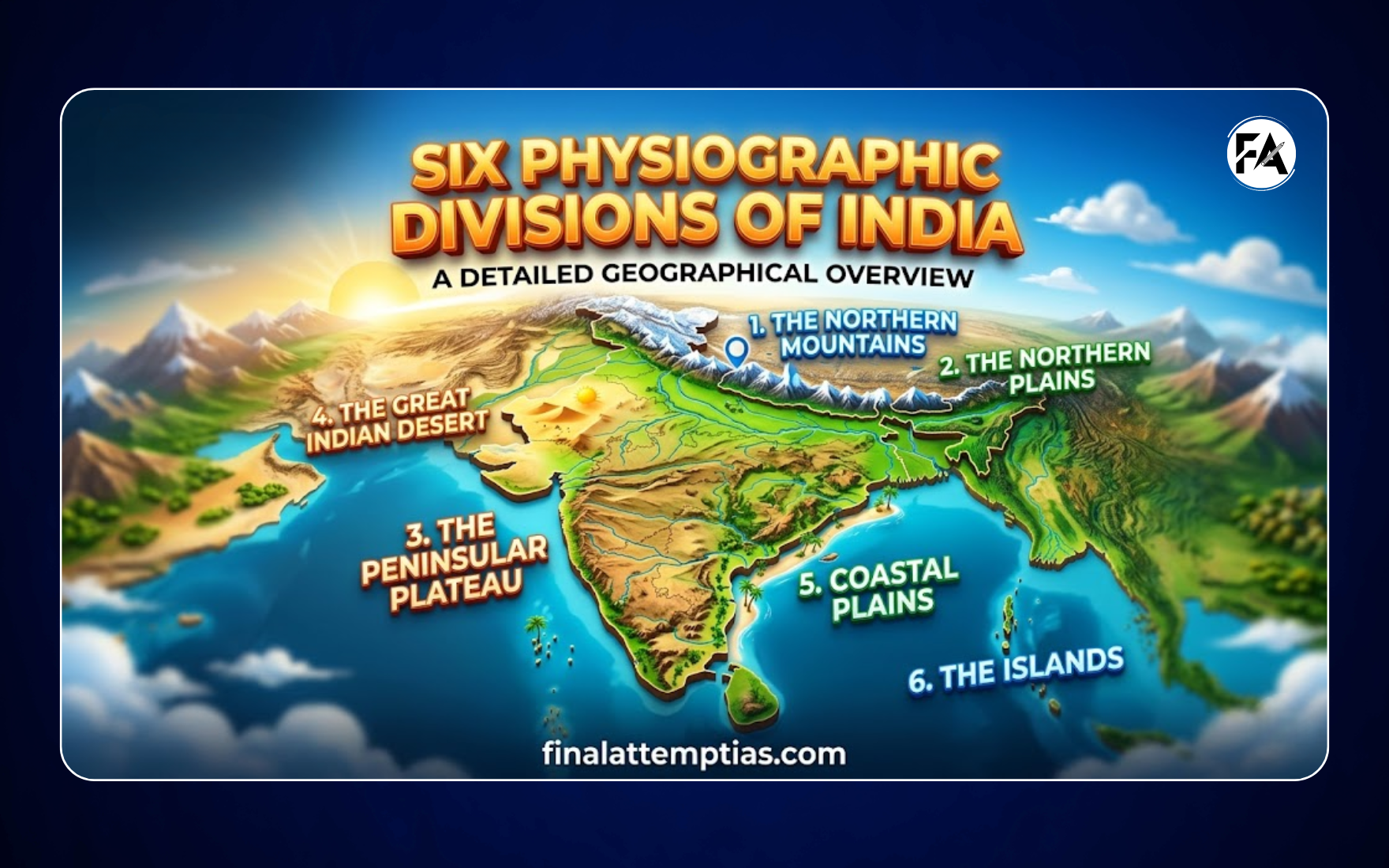
Six Physiographic Divisions of India: Map, Features & Subdivisions
India’s physical landscape is broadly classified into six major physiographic divisions, each with distinct geological structure, relief, and economic importance.
The Six Major Physiographic Divisions
- Northern and Northeastern Mountains
- Northern Plains
- Peninsular Plateau
- Great Indian Desert
- Coastal Plains
- Islands
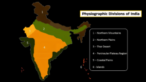
This map illustrates the six major physiographic divisions of India. These divisions represent the natural physical features of the country, including mountains, plains, plateaus, deserts, coastal areas and islands.
Important Clarifications
- The term “Northern and Northeastern Mountains” is commonly used interchangeably with the Himalayan Mountains. Both refer to the same broad region.
- Minor variations in boundaries and subdivisions may exist across sources, especially for the Peninsular Plateau and Coastal Plains.
- This article focuses on major divisions only, while detailed sub-regions are discussed separately.
1. Northern and Northeastern Mountains
This division forms the northernmost boundary of India and primarily consists of the Himalayan mountain system, along with its eastern extension into the Purvanchal Hills.
These are young fold mountains, among the highest and most rugged in the world. They play a crucial role in influencing climate, rivers, and natural protection.
Key Features
- Geologically young fold mountains
- Extend from Indus region (west) to Brahmaputra (east)
- Composed of parallel ranges with deep valleys
- Eastern extension forms Purvanchal Hills
- Act as a climatic barrier and source of major rivers
2. Northern Plains
Also known as the Indo-Gangetic-Brahmaputra Plains, this region is formed by alluvial deposits of major river systems over time.
Covering approximately 7 lakh sq km, it is one of the most fertile and densely populated regions of India.
Key Features
- Formed through river deposition
- Dominated by fertile alluvial soil
- Flat and extensive plains
- Highly suitable for agriculture
- Supports dense population
3. Peninsular Plateau
The Peninsular Plateau is an ancient and stable landmass, composed mainly of igneous and metamorphic rocks.
It is broadly divided into:
- Central Highlands
- Deccan Plateau
It also includes smaller plateaus like Malwa, Bundelkhand, Chota Nagpur, Telangana, and Karnataka.
Key Features
- One of the oldest landforms in India
- Made of hard crystalline rocks
- Features rounded hills and shallow valleys
- Rich in minerals (coal, iron, mica)
- Drained by both east-flowing and west-flowing rivers
4. Great Indian Desert
Located west of the Aravalli Hills, mainly in Rajasthan, this region is an arid sandy plain with very low rainfall.
Key Features
- Receives less than 150 mm rainfall annually
- Characterized by sand dunes
- Sparse vegetation cover
- Luni River is the main river
- Indira Gandhi Canal supports irrigation
5. Coastal Plains
These are narrow low-lying strips along:
- Arabian Sea (West Coast)
- Bay of Bengal (East Coast)
They lie between coastal mountain ranges and the sea.
Key Features
- Divided into Western and Eastern Coastal Plains
- Western coast: Narrow, includes Konkan, Kanara, Malabar
- Eastern coast: Wider, includes Utkal, Andhra, Tamil Nadu plains
- Eastern coast has large river deltas (Godavari, Krishna, Kaveri)
- Western coast has natural ports
- Important for trade, agriculture, and fisheries
6. Islands
India has two major island groups:
- Lakshadweep (Arabian Sea)
- Andaman & Nicobar Islands (Bay of Bengal)
Key Features
- Lakshadweep: Coral origin
- Andaman & Nicobar: Tectonic/island arc origin
- Rich in biodiversity
- High strategic importance
- Indira Point is the southernmost point of India
Summary Table: Physiographic Divisions of India
| Division | Area | Key Features & Facts |
|---|---|---|
| Northern & Northeastern Mountains | Along northern border from Jammu & Kashmir to Arunachal Pradesh | Young fold mountains, high relief, parallel ranges; source of Indus, Ganga, Brahmaputra; climatic barrier |
| Northern Plains | Between Himalayas and Peninsular Plateau | Flat, fertile alluvial plains; formed by major river systems; densely populated and agriculturally productive |
| Peninsular Plateau | South of Northern Plains, covering central & southern India | Old crystalline rocks; stable landmass; rich in minerals; includes Chota Nagpur Plateau |
| Great Indian Desert | Western India (Rajasthan), west of Aravallis | Arid sandy region; dunes; low rainfall; Luni River; irrigation via Indira Gandhi Canal |
| Coastal Plains | Along Arabian Sea (west) and Bay of Bengal (east) | Narrow plains; eastern coast has large deltas; western coast has natural ports |
| Islands | Arabian Sea (Lakshadweep) and Bay of Bengal (Andaman & Nicobar) | Coral and tectonic origin; strategic importance; Indira Point is southernmost point |
Significance of the Physiographic Divisions
Each division contributes uniquely to India’s geography and economy:
- Mountains → Water resources, forests, climate regulation
- Northern Plains → Agricultural backbone (food security)
- Plateau → Mineral and industrial base
- Desert → Unique ecology and irrigation development
- Coastal Plains → Trade, ports, fisheries
- Islands → Strategic and ecological importance